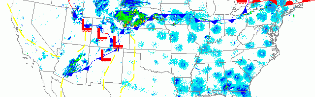
National overview
With high pressure moving out to the northeast and low pressure sliding in behind it, we saw strong migration across most of the US east of the Mississippi last night. Trans-Gulf migration continues from Texas to Florida, and Caribbean migrants continue to arrive in Florida under favorable conditions as well. Storms associated with the low over Kansas moved northeast out of the Plains into the Upper Midwest and appear to have cut off some of the northbound migration into our region. As you will see in the radar loops below, migration continues to be strongest in the southern part of the forecast area with birds still awaiting better conditions to push into the North Woods.

Below are the radar loops from sunset last night through 5:00am (central time) this morning
Upper Midwest
Minnesota & Wisconsin
Frames are every 1/2 hour. click on the thumbnail to view the full-sized animation.


Northwest winds over the Twin Cities and Duluth appear to have stifled any migration into our out of the northern reaches.


Migration over Wisconsin was again apparent in the southern half of the state, while conspicuously absent from the northern half. You can see the frontal boundary pushing north through the early morning and appearing to overtake migrants over La Crosse and Milwaukee. No fallout is evident on the images, presumably because the precipitation came late enough in the migration event and was diffuse enough not to be much of a barrier.
Iowa & Illinois
Frames are every 1/2 hour. click on the thumbnail to view the full-sized animation.


The farther south we go the better the conditions, so it’s no wonder more birds were moving over IA and IL last night. Again, many of these birds will have pushed into southern Wisconsin this morning which bodes well for a few more FOS birds here at home.
More migrants have made it into the southern portion of the forecast area and more will continue to push north into the region over the next few days. Unfortunately this latest frontal system will probably stall out and drift southward, bringing with it the increased chance of heavy precipitation. As high pressure builds to the north bringing colder air down from Canada, we may see snow and wintry mix affecting a good portion of the forecast zone. Winds on the southern edge of this boundary will be strong SW->NE which means many of the birds making their way from the Gulf states will get shunted off to our NE (into the Eastern Great Lakes region). We should see some fraction of these birds over the next week, but we’ll have to wait for this system to clear before we can expect any major influx of new birds, especially into the northern reaches of Wisconsin and Minnesota. For now, birders in the south should hit the tried and true spring migrant traps, such as Pheasant Branch Conservancy (Middleton), and Lake Farm Park (Madison) for passerines, and Nine Springs (Madison) and the Columbia County agricultural areas for waterfowl and shorebirds.
As always, woodcreeper.com depends on you to report your sightings and be our ‘eyes on the ground’, so please come back and give us an idea of how we’re doing predicting birding conditions in your neck of the woods.
Good Birding!
David
For migration updates in other regions check-
Michigan’s Upper Peninsula – The Northwoods BIRDAR by Max Henschell
New England – Tom Auer’s blog
Florida/SE – Badbirdz Reloaded by Angel and Mariel Abreu
PA/Ohio Valley – Nemesis Bird by Drew Weber
NW Ohio – Birding the Crane Creek by Kenn Kaufman
Pac NW – Birds Over Portland by Greg Haworth
Continental US – eBird BirdCast Forecast & Report by Team eBird
2 responses to “More birds into the south, pesky high pressure to the north”
I love this site! I saw your post this past weekend so I decided to go birding on Sunday at a park in west-central Indiana. Birds are definitely on the move. I counted 47 yellow-bellied sapsuckers, along with 32 golden-crowned kinglets, 6 red-breasted nuthatches, 3 hermit thrush. Then today I had 9 ruby-crowned kinglets, 5 yellow-throated warblers, and dozens of yellow-rumped warblers.
Mike-
Thanks so much for the feedback! Please keep it coming as your ground-truthing reports are the best way for us to gauge how well the forecasts are doing. Your comment got caught up in my spam filter initially but I’ve restored it now- so in the future it should post immediately.
Thanks again- and good birding!
David