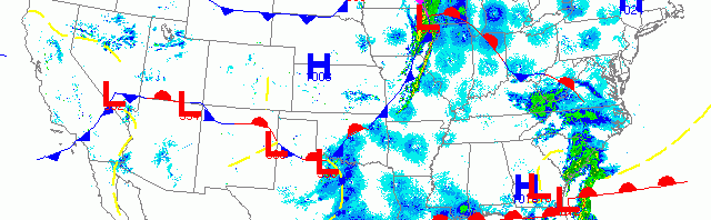
National overview
Birds were moving last night across the Central and Mississippi flyways, across the Florida Straits, and throughout the Northeast. The Upper Midwest got its first real shot of long-distance migrants last night as a cold front pushed birds to the Lake Michigan shoreline early this morning. Check out the radar below for a more detailed look at the fallout potential in Wisconsin.

Below are the radar loops from sunset last night through 5:00am (central time) this morning
Upper Midwest
Minnesota & Wisconsin
Frames are every 1/2 hour. click on the thumbnail to view the full-sized animation.


Heavy precipitation moved across Minnesota early last night, initially keeping migrants grounded. As the front passed, though, birds began arriving from the southwest into the early morning hours. Finally! Some new migrants should be evident across the region today.


Heavy migration on the leading edge of the cold front was overtaken by heavy precipitation early this morning for the eastern half of Wisconsin. The velocity image indicates that birds were being pushed to the NE over the Green Bay and Milwaukee radars. Birders in the eastern third of the state should check their local patches this morning, especially if the precipitation moved in after midnight (the peak of nocturnal migration). Birders in the Milwaukee, Sheboygan, Green Bay, and Door Peninsula areas should especially check those small forest patches near the lakeshore. Good birds are out there; go find them!
Iowa & Illinois
Frames are every 1/2 hour. click on the thumbnail to view the full-sized animation.


Migration started off quite heavy over IA and IL last night, and despite the passing front early in the night birds still appear to have continued migration on the backside of the storms. Still, if you experienced heavy precipitation around midnight, you should consider checking your local patch this morning. Otherwise tried-and-true spring hotspots should experience elevated migrant density and diversity this morning.
The first big shot-in-the-arm for Upper Midwest birders! Go out and find the birds!
As always, woodcreeper.com depends on you to report your sightings and be our ‘eyes on the ground’, so please come back and give us an idea of how we’re doing predicting birding conditions in your neck of the woods.
Good Birding,
David
For migration updates in other regions check-
Michigan’s Upper Peninsula -Â The Northwoods BIRDARÂ by Max Henschell
New England -Â Tom Auer’s blog
Florida/SE - Badbirdz Reloaded by Angel and Mariel Abreu
PA/Ohio Valley - Nemesis Bird by Drew Weber
NW Ohio - Birding the Crane Creek by Kenn Kaufman
Pac NW - Birds Over Portland by Greg Haworth
Continental US - eBird BirdCast Forecast & Report by Team eBird
One response to “Heavy migration and strong cold front cause fallout along Lake Michigan”
New BIGBY near-to-home species today: Ruby-crowned Kinglet, Hermit Thrush, Brown-headed Cowbird, Swamp Sparrow. NW Richland County