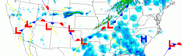
National overview
Heavy migration was apparent along the leading edge of the cold front sweeping across the Central U.S. The heaviest of this activity was across East Texas, the Southeastern U.S. and up into New York and New England. Light to moderate migration was also evident over the Southwestern U.S. as well.

Below are the radar loops from sunset last night through 5:00am (central time) this morning
Upper Midwest
Minnesota & Wisconsin
Frames are every 1/2 hour. click on the thumbnail to view the full-sized animation.


Northwest winds over much of the Upper Midwest kept birds down once again. Little-to-no migration was evident over either Duluth or the Twin Cities radar stations.


Northwest winds aloft and westerly winds at the surface, coupled with precipitation, appear to have kept birds on the ground over most of Wisconsin last night. Some small movements above each radar suggest that a few birds were testing the atmosphere last night and may have made some small shifts overnight, but otherwise expect similar birding conditions to yesterday.
Iowa & Illinois
Frames are every 1/2 hour. click on the thumbnail to view the full-sized animation.


Precipitation and opposing winds blanketed northern IA and IL, keeping any birds down on the ground last night. Expect some localized movement into more optimal foraging habitat but little else.
So because low pressure again moved southeast of the forecast region, the Upper Midwest is in another holding pattern for migration. Many birds did make it up into the region two nights ago so there are plenty of birds still to be seen (and most likely many still to be found). Birds will move into more optimal foraging habitat so locating any forested areas with recently emerged leaves will be key for finding passerines. Many of the recent arrivals are sparrows, so feeder-birding can be quite productive now.
As always, woodcreeper.com depends on you to report your sightings and be our ‘eyes on the ground’, so please come back and give us an idea of how we’re doing predicting birding conditions in your neck of the woods.
Good Birding,
David
For migration updates in other regions check-
Michigan’s Upper Peninsula -Â The Northwoods BIRDARÂ by Max Henschell
New England -Â Tom Auer’s blog
Florida/SE - Badbirdz Reloaded by Angel and Mariel Abreu
PA/Ohio Valley - Nemesis Bird by Drew Weber
NW Ohio - Birding the Crane Creek by Kenn Kaufman
Pac NW - Birds Over Portland by Greg Haworth
Continental US - eBird BirdCast Forecast & Report by Team eBird