National overview
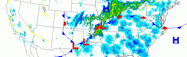
As the latest cold front marches eastward, migration continues in earnest across much of the country southeast of the frontal boundary. Trans-Gulf migrants came in high over the Texas and Louisiana coasts yesterday afternoon, and more birds poured into Florida from the Caribbean as well. Migration also continued throughout the desert Southwest and along the California up through the Pacific Northwest. Northerly winds and heavy precipitation on the backside of the front precluded any migration across the Great Plains and Upper Midwest. To see what all of this looks like put together, be sure to check out this animated loop from 3:00pm yesterday through this morning on Paul Hurtado’s radar page here.

Below are the radar loops from sunset last night through 5:00am (central time) this morning
Upper Midwest
Minnesota & Wisconsin
Frames are every 1/2 hour. click on the thumbnail to view the full-sized animation.


Heavy precipitation and NE winds kept birds down last night.


As with Minnesota, precipitation and winds kept birds on the ground last night.
Iowa & Illinois
Frames are every 1/2 hour. click on the thumbnail to view the full-sized animation.


Still north of the frontal boundary, IA and IL were covered in precipitation last night and birds stayed put through this morning.
Many birds made it into the region two nights ago, so there are still plenty of good ones around despite the lack of influx last night. The trick will be how to stay dry and warm given the overall crummy weather. If birds do move around they’ll be heading into better foraging areas; I expect those would be riparian zones with recently emerged vegetation, or newly leafed out trees.
As always, woodcreeper.com depends on you to report your sightings and be our ‘eyes on the ground’, so please come back and give us an idea of how we’re doing predicting birding conditions in your neck of the woods.
Good Birding,
David
For migration updates in other regions check-
Michigan’s Upper Peninsula -Â The Northwoods BIRDARÂ by Max Henschell
New England -Â Tom Auer’s blog
Florida/SE - Badbirdz Reloaded by Angel and Mariel Abreu
PA/Ohio Valley - Nemesis Bird by Drew Weber
NW Ohio - Birding the Crane Creek by Kenn Kaufman
Pac NW - Birds Over Portland by Greg Haworth
Continental US - eBird BirdCast Forecast & Report by Team eBird
One response to “More migration to our south as heavy precipitation precludes any influx into Upper Midwest”
[…] through the area's so keep your eyes and ears open you just never know what might fly near you. More migration to our south as heavy precipitation precludes any influx into Upper Midwest | woodcre… Live Radar page NEXRAD Archive: April 17, 2013 at 3pm ET to next day at 3pm […]