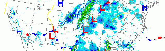
National overview
High pressure over New England and some gnarly precipitation in parts of the Southeast, Great Plains and Upper Midwest, thwarted nocturnal migration for some locales last night, but otherwise birds were on the move throughout most of the country. The heaviest returns continue to come from the Texas Gulf Coast indicating heavy Trans- and Circum-Gulf migration. Heavy migration was also apparent throughout the Midwest east of the stationary front, and along the Pacific flyway from the Desert Southwest all the way up into the Pacific Northwest. It’s clearly May, and for nocturnal migrants that means “all systems GO!”

Below are the radar loops from sunset last night through 5:00am (central time) this morning
Upper Midwest
Minnesota
Frames are every 1/2 hour. click on the thumbnail to view the full-sized animation.


You can see the frontal boundary across each of the Minnesota radars last night indicating that the front had passed to the east sometime during the day yesterday. Winds therefore were out of the north for the region which appears to have kept all but the most intrepid birds on the ground. Some migration was apparent over both the Twin Cities and Duluth, and judging by the velocity these birds appeared to be reverse migrating. Expect birding conditions to be consistent with yesterday with an additional increase in dependence on supplemental feeding (read: more birds at your feeders) due to the weather.
Wisconsin
Frames are every 1/2 hour. click on the thumbnail to view the full-sized animation.


Moderate (15 dBZ) to heavy (20-25 dBZ) migration was evident across all three Wisconsin radars last night covering 3/4 of the state (the NW corner is consistent with the Minnesota interpretation above). Precipitation appeared to be the only barrier to migration last night with birds visibly falling out again north of La Crosse and presumably along the boundary running northwest towards the Bayfield Peninsula. Birds continued to arrive into southern Wisconsin via Iowa and Illinois, and again pushed into the eastern half of the state through early this morning. All of this despite the northerly winds that kicked in last night and which have made the velocity images a bit hard to interpret.
Something interesting to visualize is how, while the surface winds were out of the north last night, as birds appear on the radar you can see that the upper level returns (the ‘outer rings’) are heading from south to north as is expected during spring migration. This is most prevalent on the Davenport, IA and  La Crosse, WI radars where the winds were strongest out of the north by sunset. This indicates how birds pushed through the headwinds to gain altitude and reach the more favorable winds aloft for migrating!
Birding conditions should be great again today, especially east of the frontal boundary. Some fallout conditions along the front are expected as well, and new long-distance migrants will be present throughout the region with the largest presence in the southeastern part of the state. Northeast winds along the Lake Michigan shoreline would usually spell doom for lakeshore hotspots, but I think because of the volume of birds in the system even those locales should see some birds today. Inland sites should rival those along the coast given the winds.
Iowa & Illinois
Frames are every 1/2 hour. click on the thumbnail to view the full-sized animation.


Again, you can see the wind shift occur over the Davenport radar in the early part of the evening, but birds took no notice of these surface winds and instead migrated high above them. Migration was moderate to heavy across both northern IA and IL and birds were headed in a generally S->N trajectory across the region. Expect some new faces (songs? plumages?) across the region today with inland hotspots being favored due to the surface winds out of the northeast.
As always, woodcreeper.com depends on you to report your sightings and be our ‘eyes on the ground’, so please come back and give us an idea of how we’re doing predicting birding conditions in your neck of the woods.
Good Birding,
David
For migration updates in other regions check-
Michigan’s Upper Peninsula -Â The Northwoods BIRDARÂ by Max Henschell
New England -Â Tom Auer’s blog
Florida/SE - Badbirdz Reloaded by Angel and Mariel Abreu
PA/Ohio Valley - Nemesis Bird by Drew Weber
NW Ohio - Birding the Crane Creek by Kenn Kaufman
Pac NW - Birds Over Portland by Greg Haworth
Continental US - eBird BirdCast Forecast & Report by Team eBird
3 responses to “More MAYgration into the Great Lakes region”
You were spot on for yesterday. Birders on the Wednesday birdwalk at our local sanctuary started seeing warblers. Yellow, Pine, Yellow rump and Black-throated Green. White crowned and white throated sparrows and a water thrush have also arrived. (Green By, Wi area)
Thanks Jeanne!
Didn’t get out for official birding but did have a FOY Baltimore Oriole in the yard. Also still having two female Purple Finches visiting the feeder since Tuesday.