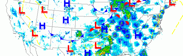
National overview
Migration was hot and heavy last night, starting with trans-Gulf arrivals to the Texas and Louisiana coasts yesterday afternoon. Birds could be seen heading up the East, Mississippi and Central Flyways with the heaviest migration over south Florida, the Mid Atlantic, and west of the Appalachians. Heavy precipitation across East Texas and the Upper Midwest caused localized fallouts where they intercepted migrating birds early this morning. Migration was moderate throughout the western U.S. including the entire Pacific Flyway.

Below are the radar loops from sunset last night through 5:00am (central time) this morning
Upper Midwest
Minnesota
Frames are every 1/2 hour. click on the thumbnail to view the full-sized animation.


Only a few birds moved over Minnesota last night as the front had already passed to the east. WNW flow over the region kept most birds down, although both radars did indicate some E->W migration after sunset. Expect conditions to be similar to yesterday with a little reshuffling of the deck as birds move into better quality stopover habitat.
Wisconsin
Frames are every 1/2 hour. click on the thumbnail to view the full-sized animation.


Precipitation kept birds down over Wisconsin last night meaning birders will see little to no change in densities and diversity across most of the state. The one exception will be the southern Lake Michigan shoreline as a few birds did push up from the Chicago area in the early morning hours. Milwaukee birders should check for concentrations at lakeshore parks today, although the magnitude of these observations is very difficult to predict because of the precipitation masking most of the bird density on the radar.
Iowa & Illinois
Frames are every 1/2 hour. click on the thumbnail to view the full-sized animation.


Precipitation moved north of the region last night allowing for migrants to push up behind it over both Davenport and Chicago. Birds over Davenport were heading NW up the Mississippi River, while those over Chicago were heading more NNE along the lakeshore. Birders in these regions should be alert to fallout conditions where precipitation was heaviest between 2am and sunrise.
As always, woodcreeper.com depends on you to report your sightings and be our ‘eyes on the ground’, so please come back and give us an idea of how we’re doing predicting birding conditions in your neck of the woods.
Good Birding,
David
For migration updates in other regions check-
Michigan’s Upper Peninsula -Â The Northwoods BIRDARÂ by Max Henschell
New England -Â Tom Auer’s blog
Florida/SE - Badbirdz Reloaded by Angel and Mariel Abreu
PA/Ohio Valley - Nemesis Bird by Drew Weber
NW Ohio - Birding the Crane Creek by Kenn Kaufman
Pac NW - Birds Over Portland by Greg Haworth
Continental US - eBird BirdCast Forecast & Report by Team eBird