National overview
Migration intensity continues to build across the U.S. with the heaviest migration occurring across the southern half of the country, as well as the Upper Midwest and Southern Canada.

Below are the radar loops from sunset last night through 5:00am (central time) this morning
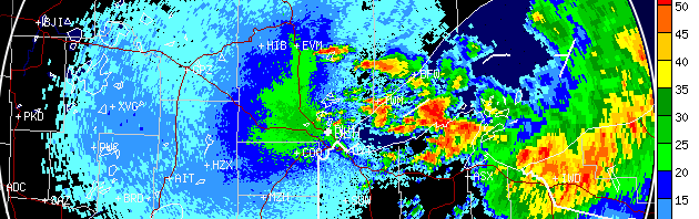
Upper Midwest
Minnesota
Frames are every 1/2 hour. click on the thumbnail to view the full-sized animation.


As a cold front dipped down into Central Minnesota and Northern Wisconsin, favorable winds brought down a nice pulse of birds into the western Lake Superior region. Check out the double-whammy on the Duluth radar, where an initial pulse of migrants after sunset is followed by a big flight of birds from farther north around 2:00am (right behind the frontal boundary and associated thunderstorms). Birders should look for concentrations of migrants along the north and south shores of Lake Superior today!
Wisconsin
Frames are every 1/2 hour. click on the thumbnail to view the full-sized animation.


Surface winds over Wisconsin were less than favorable last night, but lighter winds aloft seem to have allowed birds to move throughout the region. Check out each radar and notice how in the initial velocity images all movement across the radar is from SW->NE (with the wind). After sunset, though, birds take off and the wind vectors begin to shift to N->S. This creates a “doughnut” effect, where the “doughnut hole” are the targets moving with the wind at lower altitude, and the “doughnut” are the birds migrating higher up and heading south. Densities across Wisconsin were very light, especially compared to those over Duluth, with birds being dispersed across the landscape today.
Iowa & Illinois
Frames are every 1/2 hour. click on the thumbnail to view the full-sized animation.


A similar scenario played out over northern Iowa and Illinois, with surface winds out of the northwest and light migration of birds taking advantage of the upper level wind conditions.
As always, woodcreeper.com depends on you to report your sightings and be our ‘eyes on the ground’, so please come back and give us an idea of how we’re doing predicting birding conditions in your neck of the woods.
Good Birding,
David
For migration updates in other regions check-
Michigan’s Upper Peninsula -Â The Northwoods BIRDARÂ by Max Henschell
New England -Â Tom Auer’s blog
Florida/SE - Badbirdz Reloaded by Angel and Mariel Abreu
PA/Ohio Valley - Nemesis Bird by Drew Weber
NW Ohio - Birding the Crane Creek by Kenn Kaufman
Pac NW - Birds Over Portland by Greg Haworth
Continental US - eBird BirdCast Forecast & Report by Team eBird