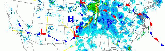
National overview
Light trans-Gulf migration along the Texas and western Louisiana coast was followed by heavy nocturnal migration up through the middle of the U.S. (>25 dBZ). The most recent front moving across the Upper Plains and Midwest packed some serious storm activity which appears to have caused fallout conditions in its path. On the backside of the front migration was light to nonexistent, while farther to the east migration continued at light to moderate densities (5-20 dBZ). Light migration was also apparent up the Pacific from Arizona to Washington State.

Below are the radar loops from sunset last night through 5:00am (central time) this morning
Upper Midwest
Minnesota
Frames are every 1/2 hour. click on the thumbnail to view the full-sized animation.


By the time night fell on Minnesota, most of the state was within the tumult of a serious low pressure system. Surface winds were light and from the east, upper-level winds were from the south, and local winds associated with thunderstorms varied depending on the position of the storm. Add to this the fact that we’re in late May with many migration-ready birds in the system and you have a recipe for a bird migration gumbo with a side of extreme weather. Both radars indicate moderate to heavy migration last night with densities fluctuating during storm passages. Birds appeared to re-emerge after passage of storms, although some localized fallout is still expected throughout the region where the heaviest storms passed between 2am and daybreak. Otherwise the main trajectory of migrants was from the SE->NW as birds piled along western Lake Superior yesterday try to push west into more substantial habitat, and birds throughout the region make their way north to the breeding grounds. Expect inland hotspots to shine this morning while densities along the Lake Superior shoreline will be lower than yesterday (but diversity will still be high).
Wisconsin
Frames are every 1/2 hour. click on the thumbnail to view the full-sized animation.


Another big flight into and out of Wisconsin last night with some heavy migration up the Lake Michigan shoreline. Birders along Lake Michigan should hit lakeside migrant traps this morning as they should be hopping with birds. Interior birders experiencing heavy precipitation between midnight and daybreak should hit local hotspots as well. We’re in the thick of migration right now and the landscape is saturated with birds. Go Birding!
Iowa & Illinois
Frames are every 1/2 hour. click on the thumbnail to view the full-sized animation.


More heavy precipitation moved into the western part of the forecast area, some of which can be seen moving across Davenport throughout the night and early morning. While many birds continued to migrate on either side of the storms, some fallout around Davenport is expected today in areas affected by precipitation between 2am and daybreak. Strong SW->NE movement over Chicago favors lakeside hotspots this morning and both density and diversity should be great there. Go Birding!
As always, woodcreeper.com depends on you to report your sightings and be our ‘eyes on the ground’, so please come back and give us an idea of how we’re doing predicting birding conditions in your neck of the woods.
Good Birding,
David
For migration updates in other regions check-
Michigan’s Upper Peninsula -Â The Northwoods BIRDARÂ by Max Henschell
New England -Â Tom Auer’s blog
Florida/SE - Badbirdz Reloaded by Angel and Mariel Abreu
PA/Ohio Valley - Nemesis Bird by Drew Weber
NW Ohio - Birding the Crane Creek by Kenn Kaufman
Pac NW - Birds Over Portland by Greg Haworth
Continental US - eBird BirdCast Forecast & Report by Team eBird