-
Late May riders on the storm
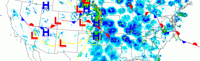
Migration activity was highest across the northern tier of states from the Great Lakes to New England last night, while birds were still on the move from South Texas up through the Central U.S. along the latest frontal boundary. Fallout conditions are possible along the frontal boundary, especially along the Lake Michigan shoreline of Wisconsin this morning. Lighter migration was also evident up through the Desert Southwest, along the Central Valley of California, and up into the Pacific Northwest.
-
Woodcreeper.com off the grid

I’ll be scouting for our Great Wisconsin Birdathon Big Day for the rest of the week, so I’ll only had intermittent internet and will likely not be able to post the radar until after the weekend. In the meantime, you can get the real-time radar at the following link: http://weather.rap.ucar.edu/radar/ and you can view the […]
-
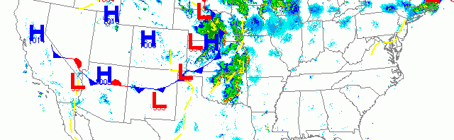
More birds and heavy precipitation moved north into the Upper Midwest
More trans-Gulf migrants made landfall yesterday morning along the Texas and Louisiana coasts, while sunset triggered another night of moderate to heavy migration across the U.S. Migration was heaviest over the Northeast and New England as well as the Upper Midwest although heavy precipitation broke things up a bit across the latter region. Birds continued to push up the western half of the U.S. with the only exception being the Rockies where northerly flow precluded any major movement.
-
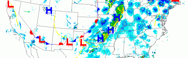
Strong low pressure brings another mass of birds to the Upper Midwest
Light trans-Gulf migration along the Texas and western Louisiana coast was followed by heavy nocturnal migration up through the middle of the U.S. (>25 dBZ). The most recent front moving across the Upper Plains and Midwest packed some serious storm activity which appears to have caused fallout conditions in its path. On the backside of the front migration was light to nonexistent, while farther to the east migration continued at light to moderate densities (5-20 dBZ). Light migration was also apparent up the Pacific from Arizona to Washington State.
-
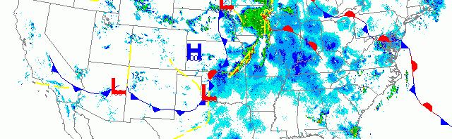
Heavy migration continues through the Upper Midwest
No trans-Gulf migration was visible on the radar last night, while nocturnal migration proceeded at break-neck pace across the eastern half of the U.S. As a new set of low pressure cells approached from the Plains region, associated southerly winds triggered heavy migration up through the central region, including Wisconsin. Light migration was also evident up through interior California and into the Pacific Northwest.