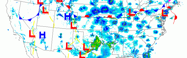
National overview
Migration was widespread yesterday, beginning with trans-Gulf movement hitting the TX/LA coast yesterday afternoon and followed by nocturnal migration across the eastern half of the U.S. and the Pacific Coast through the early morning hours. Strong westerly winds pushed birds to the Mid Atlantic coast and heavy storm activity over Texas and Oklahoma increased fallout potential for those area. Conditions over the Upper Midwest lead to some interesting patterns of migration on the radar.

Below are the radar loops from sunset last night through 5:00am (central time) this morning
Upper Midwest
Minnesota
Frames are every 1/2 hour. click on the thumbnail to view the full-sized animation.


Migration was heaviest over Minnesota where upper level winds were less northerly than over Wisconsin last night. Birds could be seen heading primarily NNE across the region and therefore turnover is expected. Because of the westerly component to upper level winds expect some concentration along the western Lake Superior shoreline this morning.
Wisconsin
Frames are every 1/2 hour. click on the thumbnail to view the full-sized animation.


A stationary front moved south of Wisconsin last night, which would typically mean stronger northerly winds to keep birds down. That wasn’t exactly the case last night as winds were light enough to allow at least some birds to migrate. Because of the mix in velocities (some wind-driven echoes moving south vs. migrating birds moving in several directions) interpreting the radar is difficult. The fact that some of the biological reflectivity reaches 30 dBZ means that we can’t just ignore it either; something interesting was going on! Looking at the La Crosse radar we can see immediate exodus after sunset with birds moving from SE->NW. The trajectory eventually moves to SW->NE before birds start dropping out abruptly around 3:00am. I interpret this as there being many migration-ready birds in the area coupled with it getting later in the spring so birds are driven to move in varying environmental conditions.
Looking at Milwaukee and Green Bay we see two more protracted migration events with birds heading in multiple directions. With all of the piling up along the lake shore the past two nights it seems logical that some of these birds want to head northeast, while others have found themselves too far east and are correcting to head to the west. In either case migration was intense early in the night and density dropped off rapidly as conditions were suboptimal for broad front migration across the region. Expect birds to still be around along the Lake Michigan shoreline, but densities to be lower and birds to have reshuffled into higher quality stopover habitat.
Iowa & Illinois
Frames are every 1/2 hour. click on the thumbnail to view the full-sized animation.


Migration over Davenport IA and Chicago IL were both protracted as well, with general movement across the radars from S->N. Light northeast winds along the lake will keep birds inland a bit making sites like Palos Woods a better bet this morning for Chicago area birders. In general, though, this pattern should mean more birds dispersed across the landscape which would favor those tried and true migrant traps which typically hold birds during spring. Hey IA and IL birders! Where ARE your spring migrant traps? Please let me know, either in the comments section of this post (preferred) or via backchannel email (david@woodcreeper.com). Thanks!
As always, woodcreeper.com depends on you to report your sightings and be our ‘eyes on the ground’, so please come back and give us an idea of how we’re doing predicting birding conditions in your neck of the woods.
Good Birding,
David
For migration updates in other regions check-
Michigan’s Upper Peninsula -Â The Northwoods BIRDARÂ by Max Henschell
New England -Â Tom Auer’s blog
Florida/SE - Badbirdz Reloaded by Angel and Mariel Abreu
PA/Ohio Valley - Nemesis Bird by Drew Weber
NW Ohio - Birding the Crane Creek by Kenn Kaufman
Pac NW - Birds Over Portland by Greg Haworth
Continental US - eBird BirdCast Forecast & Report by Team eBird
One response to “It’s mid-May, which means all systems GO!”
[…] was heavy in much of the United States overnight (woodcreeper.com, Tom Auer’s Blog). The density of birds depends on the location, generally favoring the […]